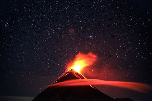
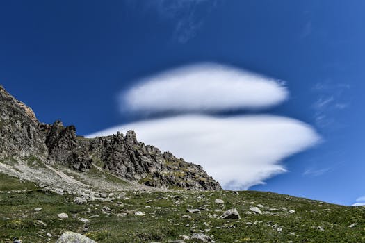
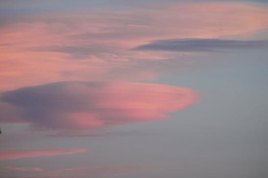
Lenticular clouds, also known as nubes lenticulares, are one of nature’s most breathtaking atmospheric phenomena. These clouds, with their distinctive lens-like shape, often captivate the attention of skywatchers and photographers alike.
Understanding the formation and characteristics of nubes lenticulares can lead to a deeper appreciation of our planet’s complex weather systems. These clouds are not just a beautiful sight to behold but also a subject of study for those intrigued by meteorological patterns.

Table of Contents
- What are nubes lenticulares?
- How do nubes lenticulares form?
- What is the meaning of nubes lenticulares?
- Are nubes lenticulares dangerous?
- What types of nubes lenticulares are there?
- Do nubes lenticulares signal rain?
- Why are nubes lenticulares common over mountains?
- Related questions about nubes lenticulares
What are nubes lenticulares?
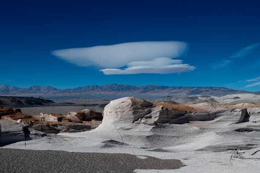
Lenticular clouds, scientifically referred to as Altocumulus lenticularis, are smooth, lens-shaped clouds that typically develop at high altitudes. They are most commonly formed over mountain ranges and can appear singularly or in stacks, like pancakes.
These disc-shaped clouds are stationary, maintaining their position despite the high winds that sculpt their unique forms. The sight of these clouds can often lead to mistaken reports of unidentified flying objects (UFOs) because of their saucer-like appearance.

While they are a stunning visual phenomenon, lenticular clouds also have practical implications. Their presence can signal atmospheric stability and may indicate underlying turbulent conditions that are particularly relevant to aviation safety.
How do nubes lenticulares form?
Nubes lenticulares form through a process known as mountain wave activity. As wind encounters a physical barrier, like a mountain range, it is forced upward, creating a series of oscillating waves in the atmosphere.
When moist air is lifted and cooled to the dew point in these waves, condensation occurs, and lenticular clouds are born. Despite the air continuing to move, these clouds appear motionless due to the resupply of moisture from the ascending air and subsequent evaporation on the downwind side.
These clouds often develop in alignment with the prevailing wind direction and can be an indicator of the strength and direction of high-altitude winds, which is valuable information for meteorologists and pilots.
What is the meaning of nubes lenticulares?
The term “nubes lenticulares” is a Spanish phrase that translates to “lenticular clouds,” emphasizing their lens-shaped structure. The name itself signifies the unique appearance and atmospheric conditions associated with their formation.
For many, the sight of lenticular clouds goes beyond their scientific explanation. These clouds can evoke a sense of wonder and are often attributed with mystical or extraterrestrial connotations due to their unusual shape.

From a meteorological perspective, nubes lenticulares mean stable atmospheric conditions and can serve as indicators of air motion and moisture at higher altitudes, which are significant factors in understanding local weather patterns.
Are nubes lenticulares dangerous?
While lenticular clouds themselves do not pose a direct danger, they are often associated with turbulent air currents that can be hazardous to aircraft. For aviators, these clouds serve as a visual indicator of potential wind shear and turbulence, particularly in mountainous regions.

Pilots are trained to recognize lenticular clouds and the atmospheric instability they can represent. Safe flying protocols may involve altering flight paths to avoid the rough air conditions that are often present in the vicinity of these captivating clouds.
Nevertheless, for those on the ground, lenticular clouds are harmless and provide a spectacular visual treat, especially during sunrise and sunset when they can be illuminated with vibrant colors.

What types of nubes lenticulares are there?
Lenticular clouds are categorized based on their altitude and appearance, with the main types being Altocumulus standing lenticularis (ACSL), Stratocumulus standing lenticular (SCSL), and Cirrocumulus standing lenticular (CCSL).
- Altocumulus standing lenticularis are mid-level clouds that form between 6,500 and 20,000 feet.
- Stratocumulus standing lenticular are found at lower altitudes, up to 6,500 feet.
- Cirrocumulus standing lenticular occur at higher altitudes, above 20,000 feet.
Each type of lenticular cloud is associated with specific atmospheric conditions and may vary in color, thickness, and size. Observing these different types can provide insights into the atmospheric layers and the dynamics of air movement within them.
Do nubes lenticulares signal rain?
Lenticular clouds are not typically associated with rain. They form under stable atmospheric conditions where air flows smoothly over mountains, leading to their distinctive shapes without the development of precipitation.
These clouds are more indicative of dry conditions, as the air tends to descend on the leeward side of the mountain, warming and inhibiting cloud formation. However, they may precede a change in weather patterns, as they often occur on the periphery of frontal systems.
It’s important to note that while they do not signal rain, their presence can highlight complex air movements and moisture levels at altitude, offering clues to broader weather conditions.
Why are nubes lenticulares common over mountains?
The presence of mountains acts as a natural barrier that disrupts the horizontal flow of air, leading to the formation of lenticular clouds. Mountain wave activity is a primary driver for their development.
As air travels along the Earth’s surface, encountering a mountain forces it to rise sharply. If the atmospheric conditions are right, with sufficient moisture and a stable temperature gradient, the air cools to the point of condensation, forming clouds.
This process is particularly pronounced when there are strong, stable winds perpendicular to the mountain range, making locations with these geographical and meteorological conditions hotspots for observing nubes lenticulares.

Related questions about nubes lenticulares
What do lenticular clouds signify?
Lenticular clouds signify stable atmospheric conditions and are often associated with mountain wave activity. They indicate a moist layer of air at a certain altitude, which has been lifted and cooled to form distinct, stationary cloud formations.
These clouds are also a sign for pilots to anticipate possible turbulence, despite the serene appearance of the clouds themselves. Their presence is a reminder of the dynamic interactions between the Earth’s surface and the atmosphere.

Do lenticular clouds mean rain?
Generally, lenticular clouds do not mean rain. They form under stable conditions where air descends on the downwind side of mountains, which typically leads to drier air and a lack of precipitation. While they do not indicate imminent rainfall, their occurrence can reflect broader atmospheric conditions that may influence local weather patterns.
What are the three types of clouds?
The three primary types of clouds are classified based on their altitude: cumulus, stratus, and cirrus. Each category has several subtypes, with lenticular clouds falling under the Altocumulus category but specifically distinguished by their unique lens shape and stationary nature.

What do circle-shaped clouds mean?
Circle-shaped clouds, like lenticular clouds, are often a result of specific atmospheric conditions. They can indicate areas of significant updraft and may be associated with thermal columns or other localized meteorological phenomena. These shapes can also be formed by various types of cloud seeding or other artificial interventions in the atmosphere.